Enregistrez gratuitement cette image
en 800 pixels pour usage maquette
(click droit, Enregistrer l'image sous...)
|
|
Réf : T03009
Thème :
Terre vue de l'espace - Volcans (181 images)
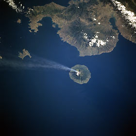
Titre : Sangeang Island, Api Volcano, Indonesia July 1997
Description : (La description de cette image n'existe qu'en anglais)
This southwest-looking view shows the Indonesian island of Sangeang, and a smoke cloud blowing in a southeasterly direction from Api Volcano. Sangeang is an 8-mile (13 km) wide island that is located off the northeast coast of Sumbawa Island (top of image). Api is one of the most active volcanoes in the Lesser Sunda Islands. The volcano is made up of two volcanic cones, the highest being Mount Dori at 6393 feet (1949 meters) above sea level. Intermittent historical eruptions of Api Volcano have been recorded since 1512, but most occurred during the 20th Century. To the left (southeast) of Sangeang Island is Banta Island, the remains of a former volcano. Though partially cloud covered, the Sape Strait is discernible in the upper left corner of the image. Bima Bay on the island of Sumbawa is visible in the upper right portion of the image.
|
|

